All Posts (77)

Sort by

Hiking Point Reyes Tule Elk Reserve

We round a curve and halt.  A herd of 50 female tule elk crosses our trail.  There 10474486276?profile=originalare three males.  Two are smaller, but one is massive, standing tall above his harem, with a huge candelabra rack, seven points on each antler.  He looks like he is having a very good year.

It is late October, the tail-end of rutting/breeding season, as we hike the northern tip of Point Reyes National Seashore on Tomales Point Trail.  A narrow peninsula, it is bordered by steep cliffs and the wild Pacific to the west, and to the east, the calm waters of Tomales Bay and the rolling hills of Marin.

Tule elk once rambled California’s coastal hills and Central Valley.  It is estimated10474486065?profile=original that there were 500,000 when Europeans arrived.  They were hunted relentlessly, and by the 1860s they were thought to be extinct.  But in 1874, a group of less than 30 was discovered in the marshes of southern San Joaquin Valley.  Rancher, Henry Miller, protected them, and they started to make a comeback.

In the fall of 1978, 17 tule elk were released into the 2,600 acre enclosed reserve at Pt. Reyes.  The population grew, and today it is estimated at 450.  In 1998, 28 elk were 10474485892?profile=originalmoved to the Limantour Beach area.  The herd grew, and a group swam across Drakes Estero and established a sub-head near Drakes Beach.  Around 4,300 tule elk now live in 15-20 California sites.

Rutting and breeding season extends from August into October, and this is an exciting time to hike the reserve.  Female hormones are pumping.  Bulls attract females by bugling and then chase off other males to10474486301?profile=original form harems of up to 30-50.  After the rut, males form bachelor groups, and in the winter, they lose their antlers.

Females remain in groups throughout the year, except between mid-May and mid-June when a pregnant cow separates to give birth.  She returns to the group after about 3 weeks with her calf.

A mile later, we see a coyote, light brown, healthy and proud.  He prances along the grassy hillside, then stops and starts to stalk.  He freezes, then pounces.  A ground squirrel locked firmly in his jaws; he strolls over the crest and disappears.

We continue to the end of the peninsula, hiking trails through grassland, coyote 10474486676?profile=originalbrush, lupine, Douglas iris, and wild radish.  Red-tailed hawks, kestrels, and vultures circle overhead.  It is a nine mile round trip.

On our hike back, we spot 20 bachelors, 7 feet long and 4-5 feet tall at the shoulders, sporting coats of beige, dark brown manes, tan rumps, and impressive racks.  They gather round a small tarn, grazing and 10474486090?profile=originallounging while mallards swim in the shallows and an egret hunts along the shore.

We approach cautiously, but they are unconcerned.  Roosevelt elk and Rocky Mountain elk inhabit other national parks, but Pt. Reyes National Seashore, is the only one where tule elk roam, and they know they have nothing to fear from humans.  Our trail passes within a stones-throw of the pond.  We sit for a while before heading back to civilization, taking in this wildlife experience, feeling grateful that these 10474486467?profile=originalmagnificent creatures have endured.

Point Reyes is about 1.5 hours north of San Francisco.  To reach the Tule Elk Reserve, take Sir Francis Drake Blvd. into the park.  Continue on Sir Francis Drake along the western edge of Tomales Bay and through Inverness.  Turn right on Pierce Point Road and drive to the end at Historic Pierce Point Ranch.  Tomales Point Trail starts from the parking area.

Docent led tours are available during rutting season.  For more information, go to the park’s website, or call 415-464-5100.

Read more…

La Jolla to Mexico - Hiking Inn-to-Inn

Stand on cliffs overlooking La Jolla Bay, and take in the abundance of wildlife.  10474484276?profile=originalMigrating whales feed close to shore.  Sea lions bark a noisy chorus from offshore outcroppings.  Harbor seals lounge on sheltered beaches.  Dolphins, leopard sharks, shovel-nose guitarfish, and Garibaldi damselfish ply the clear waters.

     Then set out on the final leg of a 200 mile inn-to-inn hiking adventure from North L.A. County to the border with Mexico.  You will hike rugged, rocky coastlines and sublime swimming beaches, on this 32-mile,10474484872?profile=original 5-day sojourn.  Pass through working class seaside villages and elegant upscale towns, offering great cuisine, interesting inns, and always – the wild Pacific.

     After taking advantage of La Jolla’s many restaurants and taverns, hike the first day (5.1 miles) along the rugged coastline, sheer cliffs, pocket coves, and inviting beaches of La Jolla Peninsula.  End the day in Pacific Beach, popular with surfers and sun worshippers.  Take a swim.  Then grab a table at a sidewalk cafe and enjoy the 10474484661?profile=originalpeople-watching parade along the strand.

     Hike coastal beaches and the north shore of San Diego Bay on Day 2 (8.5 miles) and Day 3 (6.8 miles).  A ferry takes you across the bay to Coronado.  The Hotel del Coronado is one of the largest and oldest wooden structures in California.  Ornate and regal, it is worth a visit.  Stroll the grounds.  Have a drink at the outdoor beach-side bar.  Then enjoy a balmy evening in the surrounding village – shops, bars with live music, and 10474484897?profile=originalrestaurants with sidewalk tables.

     Day 4 hikes the Silver Strand, an eight-mile long and quarter mile wide strip of sand dune separating San Diego Bay from the Pacific.  You will probably have this beautiful beach all to yourself, sharing it only with flocks of snowy plover and marbled godwits.  There is no hurry.  Slow down.  Savor a deep connection with the powerful Pacific.

     10474484686?profile=originalArrive in Imperial Beach, a slow moving, working class hamlet, the last stop before Mexico.  Enjoy a swim on the beautiful beach. Then take a long walk to the end of the pier and feast on fish tacos and crab cakes at Tin Fish Restaurant, or saddle up to the bar of IB Forum, “the most southwesterly bar and grill in the continental U.S.A.,” for steaks, burgers, or 10474485261?profile=originalseafood.

     It is only 3.3 miles to the border, a 6.6 mile round trip.  The estuary, marshland, and sand dunes of Border Field State Park flank the beach, a protected refuge rich with birdlife.  You will reach the Tijuana River, and this may end your journey.  But in late summer and fall, it runs shallow and can be waded.  The river’s mouth teems with pelicans, cormorants, gulls, egrets, and endangered least terns and snowy plover.  The terns make an incredible racket, 10474484301?profile=originalchattering and screeching.         

     You will probably have the final 1.6 miles of this serene beach to yourself.  Reaching the border fence, pause to take in the moment and relish the memory of a five-day adventure along America’s southwestern edge, hiking inn-to-inn.

The La Jolla to Mexico Walkabout is one of the multi-day hikes found in “Walkabout Malibu to Mexico: Hiking Inn-to-Inn on the Southern CA Coast”.  It can also be purchased as an individual guide.

$6.99

10474459675?profile=original

Read more…

From San Francisco’s Cliff House, Ocean Beach beckons.  Broad and flat, it stretches as far as you can see, disappearing into the mist.  Stride out on 9 miles of10474485663?profile=original uninterrupted beach to start this 30-mile, 4-day walkabout.  Urban life fades as you hike a coast that is extraordinarily wild.

     Hike miles of solitary beaches, the flanks of coastal mountains, and bluff trails above the wild Pacific.  Enjoy interesting inns and delightful coastal villages along the way.

     What joy to hike for hours along the immense and powerful Pacific.  Day 1 (13.6 miles) ends in the 10474485865?profile=originalcoastal hamlet, Pacifica.  Perhaps you’ll take a swim and then savor a fresh catch-of-the-day at a restaurant overlooking the sea. 

     Day 2 (7.8 miles) journeys up the side of Montara Mountain.  Views open to the narrow10474485688?profile=original channel of the Golden Gate and the steep, forested hills of the Marin Headlands.  The vast Pacific stretches out below you, the horizon only interrupted on a clear day by the Farallon Islands, ancient mountain peaks jutting out of the sea 27 miles offshore.  

     Walk the bluffs and cypress forests above Fitzgerald Marine Reserve on Day 3 (4.0 miles).  Take a path to the shore and explore the intricate web of tide pools alive with green anemone, orange sea stars, and scurrying crabs.  Harbor seals, pelicans, egrets, cormorants, grebes, and countless shorebirds feed on the reefs and offshore waters.  End the day in Pillar Point Harbor, a seaside village of inns, restaurants, and taverns with live music.

     Enjoy another long beach stroll on Day 4 (4.6 miles).  You may want to walk barefoot and 10474485100?profile=originalconnect deeply with sand and surf.  You will soon return to the urban ramble, but now you can savor hiking inn-to-inn from San Francisco to Half Moon Bay.


This is one of the most popular Northern California inn-to-inn hikes.  Read about the ideas and adventures from the Walkabout Community on the Forum.

The San Francisco to Half Moon Bay Walkabout is one of a dozen inn-to-inn hikes found in “Walkabout Northern California: Hiking Inn to Inn”.  It can also be purchased as an individual guide.

$6.99

10474459675?profile=original

Read more…

Driving across the Sierra Nevada Mountains and need to stretch your legs?  Take10474475075?profile=original this short and beautiful High Sierra hike to two pretty alpine lakes.

We hiked this trail in late July.  It was still spring time in the high country.  The wildflowers were spectacular, and they should continue into late August. 

Start at Carson Pass (8,574’) from the parking area at the crest of Highway 88, and head south on the Pacific Crest Trail, gradually ascending through a forest of western white pines.  The hike to Winnemucca Lake (8,980’) is 2.4 miles, and Round Top Lake (9,364’) is another mile.

The forest thins as you hike, and the terrain turns to grassy mountain sides.  Round Top Mountain comes into view, raw granite graced with snowfields.  After a mile, you 10474474879?profile=originalpass by Frog Lake, a short detour from the trail.  The PCT veers to the west, but we follow the signs to Winnemucca Lake.

Snowmelt moistens the soil, and we hiked through vast wildflower gardens – deep blue lupine, yellow mules ear, white cow parsnips, wild iris, red paint brush.  We spotted blue elephant heads along a stream with clusters of flowers shaped like its name.

Winnemucca Lake sits at the base of Round Top Mountain.  Streams of melted snow feed it.  The very brave can take a10474475477?profile=original refreshing swim.

Most hikers turn back here.  A few continue on to Round Top Lake.  It is worth the effort.  Even if you don’t go on, walk to Winnemucca’s south west corner where a stream flows out of the lake and water pours down the mountainside from snowfields.  Here the wildflowers are in their full glory. 

10474475853?profile=originalThe trail climbs more steeply to Round Top Lake.  Whitebark pines, some of the highest elevation pines in the Sierra, bend and bow to the east, weathered by gales that howl through this pass.

Hike over the crest, and the view of Round Top Lake will take your breath away.  A crystalline lake surrounded by green fields and pines, it is nestled at the base of10474475281?profile=original The Sisters, rugged granite peaks with deep snowfields that should last until they are replenished by next winter’s storms.  We walked along the shoreline and stopped for a picnic, just enjoying the beautiful scene.

The hike back is downhill and should take 1 – 1.5 hours.  What 10474476460?profile=originala wonderful way to break up your drive across the Sierra Nevada Mountains.


Walkabout California – connecting with the natural world through travel, outdoor adventure, and hiking inn-to-inn.  Savor the journey and the destination. Click here for California inn-to-inn hiking guides.

Read more…

Hiking Cinque Terre

Cinque Terre is the jewel of the Italian Riviera.  Rugged mountains plunge to the Ligurian Sea where five medieval coastal villages, each with its own dialect and 10474478066?profile=originalidentity, enchant visitors.  Come for the swimming, the sun, the wine, and for hiking.

The car-free villages are connected by a web of trails.  They are close enough for hiking to multiple villages in a day and returning to your base by ferry or rail.  We chose to take it slow, to connect to this land in an intimate way, to hike from south to north, staying overnight in each village along the way. 

Summer along this coast can be sweltering and crowded.  April, May, September, 10474478460?profile=originaland October are prime months for a relaxing visit.  We hiked Cinque Terre in October.  While sipping a latte at a sidewalk café, we were able to book our rooms on-line a day or two in advance.  (For lodging and transportation information, see below.)


Riomaggiore

Riomaggiore is Cinque Terre’s southernmost town.  Arriving by train from La Spezia, we walked to the harbor down the ravine that forms the main street. 10474478288?profile=original Ancient pastel multi-storied houses, built into steep hillsides, line the street.  Small fishing boats were stacked in the piazza at the base of the harbor.

          After checking into our hotel, we headed to the rocky beach for an afternoon swim in the warm, aquamarine sea.  That evening we explored the town, stopping at a sidewalk cafés where we were introduced to Cinque Terre wine – white, crisp, and dry.  We dined, as we 10474478092?profile=originaldid every night on this journey, on the fresh catch-of-the-day.


Hiking Day #1 Riomaggiore to Manarola

The coastal trail, Via dell’Amore, is closed due to landslides.  When it was open, the paved and flat walk from Riomaggiore to Manarola took 20 minutes.  Ladies strolled it in high heels!  It is projected to reopen in 2018.

          The route now takes trail 531 by walking up through town, past the train station.  Climb Via Signorini around a hairpin turn and follow the sign for “Manarola” leading you along a narrow road.  The trailhead marker is on the left. 10474478664?profile=original It is always easy to find the trailheads by asking at the tourist office where you can also pick up a map.  Or you can ask a local.  Even if you don’t speak Italian, they will see that you are a hiker and point you in the right direction.

          This is the most challenging of all the trails we hiked in Cinque Terre.  It starts with a long, steep ascent.  For me, this is the most difficult type of trail – tall stone steps, 12-18 inches high.  It is good to wear hiking boots, and we were grateful to have our hiking poles.

 10474478867?profile=original         The climb is worth the effort.  The trail ascends through land cultivated for centuries.  These venerable trails were originated by farmers in Roman times who climbed to their terraced gardens and vineyards.  Farmers still use them today.  The autumn plots were dense with lettuce, onions, and huge squash.  Lemons ripened and the grape harvest was winding up.

          As you ascend, beautiful views unfold of forested mountains, the undulating coastline, villages clinging to the cliffs, and the Ligurian Sea.  Not a good trail for 10474478690?profile=originalthose with vertigo, at times the narrow path is wedged between a stone wall and a precipitous cliff.  Descend into Manarola on steep stairs.  The hike should take 1.5-3 hours.


Manarola

The brightly colored houses of Manarola wind down a narrow ravine and extend to a rocky promontory overlooking the sea.  Small fishing boats line the street near the 10474479066?profile=originalharbor.  The concrete pier and adjacent rocks are a great place to swim.

          A peaceful fishing village famous for its wine, it has several wine shops and restaurants.  Tourists come in for short visits by train or ferry, but it is quiet and serene after sunset. 

          We took an evening stroll and stopped at a wine shop.  Antonio was behind the bar of the shop his grandfather opened in 1958.  He served us a selection from nearby vineyards along with the typical snacks – olives, capers, and nuts.  Somehow the10474478892?profile=original wine was even more delicious knowing it might have come from the vineyards we had hiked through that day.


Hiking Day #2 Manarola to Corniglia

The low coastal trail from Manarola to Corniglia is also closed due to landslides, so our trail heads for the hills.  The ascent is steep, but easier than the first day because the steps are shorter.

 10474479267?profile=original         It climbs to Volastra, passing through vineyards on timeworn terraced paths.  The grapes had been harvested, and the vines were turning to yellow.  Olive groves were leaden, and olives dropped into nets below the trees.

          You can stop at a restaurant in Volastra for refreshments.  The trail then winds for a long flat stretch in and out of the woods.  There are spectacular views of the coastline north and south where you can spot all five villages.  The hike is 3.2km10474479093?profile=original and should take 1.5 - 2.5 hours.


Corniglia

The smallest of the five villages, Corniglia has a unique non-touristed quality.  Set on cliffs, 100 meters above the sea, it is the only Cinque Terre village where the ferry doesn’t stop.

 10474479468?profile=original         A deep ravine divides the town.  It has a central square and one main street with shops and restaurants.  Corniglia’s wine was the most celebrated during Roman times, and it is still delicious 2,000 years later.  After sunset, the village has a quiet, timeless feel. 


Hiking Day #3 Corniglia to Vernazza

Take the main street north out of town.  The trail climbs, but it is a gradual ascent with breathtaking views looking back to Corniglia and Manarola.  It passes through10474478486?profile=original vineyards and groves of scrub oaks.  Prickly pear cactus and century plants with long flower stalks cling to steep mountainsides.

          We took a break near the top of the trail at a little shop that serves snacks and cold drinks with a deck overlooking the beautiful coastline.  Hikers from Europe and the Americas had also stopped.  We lingered, sharing stories of European hiking adventures.

 10474479661?profile=original         The trail descends steeply into Vernazza with a series of sharp switchbacks.  Rock steps on the trail were slippery from the last night’s rain.  It required more mindful hiking.  The hike is 3.6km and should take 1.5 – 2.5 hours.


Vernazza

Like other Cinque Terre villages, Vernazza is built along a ravine where mountain runoff flows to the sea.  Yellow and rose houses climb the hillside.  Shops and restaurants line the10474479686?profile=original main street that is built over the ravine.  On October 25, 2011 a freak torrential downpour brought rivers of mud flooding the streets of Vernazza, wiping out the railroad tracks and burying shops and houses under 13 feet of muck and debris.

          It took months to dig out, but the village has recovered.  Vernazza’s rocky peninsula, topped by a castle, extends into the sea.  A concrete and rock breakwater forms a tranquil harbor.  High seas pounded the rocks during 10474479861?profile=originalour visit, and most of the fishing boats were pulled up onto the piazza. 

We explored the town, climbing to the old cemetery.  Walls of vaults held the remains of loved ones with photographs of those who had died in more recent decades.  They give a sense of village and family life over the years.

After a walk on the rocky beach, we watched the sunset from a sidewalk café on the harbor piazza.  Waves crashed on the rocks and cascaded over the seawall.  Then we climbed stairs of the peninsula to a restaurant overlooking the sea where we 10474479292?profile=originaldined Italian style, a two hour feast of salad, pasta, clams, sea bass, and Cinque Terre wine.

Hiking Day #4 Vernazza to Monterosso al Mare

This may be the most popular section of the Cinque Terre trails and for good reason.  The trail ascends steep steps then winds along the mountainside with the most awe-inspiring views of all five villages and the coast.  There are segments of the trail only wide enough for one person.  Hikers are traveling in both directions, so there may be periodic traffic jams.

10474479886?profile=original          Monterosso al Mare comes into view, set in a picturesque cove with a crescent coastline leading to a monolithic rocky peninsula.  Enter the fifth village on a walkway built into the cliff face, a dramatic finale to a hike along the Italian Riviera.


Monterosso al Mare

Arriving in Monterosso al Mare after hiking Cinque Terre feels like leaving an10474479493?profile=original ancient world and reentering the 21st Century, although a very pleasant version of it.  A resort town with large hotels and a long sandy beach, it is the most visited of the five villages.

          The old and new sections of town are linked by a pedestrian tunnel.  Explore Monterosso al Mare with a visit to the partially ruined Genoese castle and the church of San Francesco, built in 1622, which 10474480468?profile=originalhouses a painting of the crucifixion attributed to Van Dyke.  Then enjoy the beach and nightlife.


Transportation

Driving the winding roads of Cinque Terre can be thrilling if you are not subject to carsickness.  The towns are car-free, but each has parking on the outskirts.  You may pay a hefty fee to park within 1 km of your inn or you might find a free spot further away.  Park once and then get around by train, ferry, or on foot.

          Take the train from La Spezia or Genova.  Each village has a train station, and10474480493?profile=original local trains run 1-2 times an hour in each direction.  Tickets cost 1.5 – 3 euros.

          Travel by ferry between all the villages except Croniglia.  It is a spectacular way to explore the coast.  Hike to one or two villages, 10474480263?profile=originaland return to your home base by train or ferry.


Lodging

We hiked Cinque Terre in October, and we were able to book a room one or two days in advance.  If you are traveling during the busy summer season, make your bookings several weeks ahead.  The most popular methods are Booking.com, Airbnb, or the recommendations of Rick Steves and Lonely Planet.

Read more…

Gliding peacefully across Utica Reservoir, high in the Sierra Nevada Mountains.  Boulders, deep below the surface catch the morning sun in the clear waters.  An 10474484073?profile=originalosprey circles overhead, intently searching for breakfast.  Our kayaks and paddles are all that disturbs the still surface.

Three easily accessed lakes in Carson-Iceberg Wilderness, Utica Reservoir, Union Reservoir, and Spicer Meadow Reservoir offer wonderful camping, kayaking, and canoeing.  (See directions below.)  There are scores of campsites in Forest Service campgrounds and walk-in, drive-to sites around the lakes.  Or, launch your kayak and find a site along the shore or on one of dozens of islands.  Be sure to bring your own drinking water or a water purifier.

Our campsite overlooks Utica Reservoir.  Its shore is lined with pines, junipers, 10474484097?profile=originaland glacial polished granite.  A pair of paddle boarders pass by as we prepare our kayaks, and a gaggle of curious Canada geese swim over to see what we are up to.
          We launch, paddling along the shore, and when the sun warms us, we stop at an island for a swim.  It is mid-June.  Diving off rocks into the brisk water, we do not linger.  Come July the water will be warm enough for a long swim.10474484472?profile=original

Turning up an arm of the lake, we beach at the base of a stream.  A mother mallard shepherds her brood of eight chicks.  One strays too far and then skitters back across the surface to the safety of mom’s protection. 

We set out on foot up stream to Union Reservoir.  Hiking over raw granite, we spend a few hours 10474483686?profile=originalexploring the shoreline.

A westerly, afternoon breeze has kicked up.  Heading into the wind, the journey back takes a bit more effort, but it is still a joy to be paddling in paradise.


Bring the Kids

The three lakes are great for family camping with or without a boat.  There are endless opportunities for water play and exploring.


Directions

The lakes are approximately 3 hours from the Bay Area and 2.5 hours from Sacramento.  Take Hwy. 4 west into the Sierra.  You will pass by Angels Camp, through Murphys and Arnold.  Turn right10474484497?profile=original on Spicer Reservoir Rd., 22 miles east of Arnold.  Turn left on Forest Service Road 7N75 to reach Utica and Union Reservoirs.  Continue on Spicer Reservoir Rd. to reach Spicer Meadow Reservoir.


Equipment Rental

Rent kayaks and paddle boards in Arnold at Sierra Nevada Adventure Company (209)795-9310.  Even if you don’t have a car rack, they can set you up.

Read more…

A Day Hike Deep Into Desolation Wilderness

Desolation Wilderness is a land of spectacular beauty.  Soaring peaks of granite, honeycombed with scores of lakes, it towers over the southwest corner of Lake 10474476285?profile=originalTahoe.  This High Sierra Nevada, 7 mile round-trip hike takes you to Lake Aloha and the heart of Desolation Wilderness.

Leave Hwy. 50 at Echo summit and take a short drive through pine forest to Echo Lake.  Echo Chalet (www.echochalet.com, 530-659-7207) provides a boat taxi across Lower and Upper Echo Lakes.  The 15 minute boat trip costs $14 per person each way, but it cuts off 2.5 miles of hiking coming and going.  You can buy a topo map 10474476485?profile=originaland load up with snacks for the trail at the Chalet’s store.


Sierra Spring

It was early spring in the high country, mid-June, when Heidi and I set out.  A stiff westerly wind blew down Lower Echo Lake, and the water taxi was grounded.  It was beautiful day, and the extra 5 miles felt like a bonus.  We were in no hurry.  It would stay light until after 9pm.10474477089?profile=original

Leaving the chalet on the Pacific Crest Trail, cross a spillway and hike above the north shore of Lower and Upper Echo Lakes at 7,539’.  The flat, soft gravel trail is ideal for striding out.  After Upper Echo Lake, the PCT gradually ascends through open country.  The surface turns to loose rock, and you need to be more mindful of your footing.

Look back to beautiful views of Echo Lakes, deep blue and shimmering, nestled in 10474476886?profile=originala long valley, surrounded by snowy forested peaks.  Ancient, stately junipers with deep red bark cling to cracks in granite cliffs. 

Once again, I salute the founders of the PCT for finding the most beautiful route.

A mile after leaving Upper Echo Lake, the trail passes by Tamarack Lake at the base of Ralston Peak.  Seasonal rivers of snowmelt raged across the trail, and sometimes the trail became a stream.10474476658?profile=original

Entering a forest of white fir and lodgepole pine, we hiked over patches of snow.  Early Sierra wildflowers were starting to bloom, but the most stunning was the snow plant.  It emerges from ground freshly cleared of snow, bright red with an intricate spiraling architecture. The Latin name Sarcodes Sanguinea means “bright flesh-like thing.”  It has no chlorophyll and is nourished by fungi in the soil.

Reaching 8,300’, we ran into serious snow.  When I had called Echo Chalet, they had said, yes the water taxi was running, and yes 10474477486?profile=originalpeople were hiking into Lake Aloha.  They hadn’t mentioned the snow. 

For the last mile to Lake Aloha, we hiked over snow that was at times 12’ deep.  It was firm with a soft top layer, and nice hiking surface.  The boot prints of earlier hikers guided us.  We passed a small lake still half frozen.  This year, the snow should be melted from the trial in early July.

After a short descent, we reached Lake Aloha at 8,120’. It sits in a glacial basin surrounded by raw granite peaks – Mt. Price 9,975’, Mt. Agassiz 9,967’, and Pyramid Peak 9,983’.  Mother Nature has outdone herself, an immense canvas painted with a glacial brush.

  Rivers of snowmelt poured into Lake Aloha.  It is a vast lake when it fills, 10474477264?profile=originalpeppered with hundreds of granite islands.  Now, early in the season, it is a labyrinth of ponds and channels winding through fissures in the rock.  We explored for a few hours, following seasonal rivers, venturing into the lake on rocky peninsulas before heading back.


Sierra Fall

Late last August, my friend Scott and I hiked to Lake Aloha.  The water taxi was running, an exhilarating ride that saved us 2.5 miles each way.

10474477861?profile=originalThe trail was dry and there was a feel of early autumn in the air.  Lake Aloha was weeks past its full stage.  Snowmelt had drained into Pyramid Creek, over Horsetail Falls, and joined the South Fork of the American River. 

We swam in deep pools, explored tiny islands, and dried off on smooth, sunbaked granite.  Then we headed back to catch the last call for the water taxi at 5:00.10474476685?profile=original


Directions

Echo Lake is approximately 10 miles west of So. Lake Tahoe off of Hwy 50.  It is a 3-4 hour drive from the Bay Area depending on traffic.  Detailed directions.


Walkabout California – connecting with the natural world through travel, outdoor adventure, and hiking inn-to-inn.  Savor the journey and the destination. Click here for California inn-to-inn hiking guides.

Save

Read more…

Hiking el Camino de Santiago de Compostela

At a communal dinner, the night before we are to set out, our host asks us to each say why we are walking el Camino de Santiago. Everyone has a reason, usually a life change – recovering from a recent divorce, mourning the loss of a loved one,10474480671?profile=original frustration with a job and the need for change, trying to figure out what to do with one’s life.

For me, I had just retired and “Walkabout Northern California: Hiking Inn-to-Inn” had been published in the spring.  I decided to give myself the gift of a 500 mile trek across Northern Spain.

Our host tells us, “There are almost as many reasons for hiking the Camino as there are pilgrims,”

 The legend of the Camino began in 813 when Pelayo, a religious hermit, heard the song of angels and followed a star to an ancient Roman mausoleum where he found the remains of St. James, one of Jesus´ apostles.  His finding was confirmed by the local bishop and the Asturian King, Alfonso the Chaste.  Soon pilgrims flocked to the site as a form of penance and to earn an indulgence, a free ticket to heaven.  The pilgrimage route flourished from the 11th to 13th centuries when 10474480696?profile=originaltowns, churches, monasteries, and services for pilgrims were established.  As the centuries passed, there were times when very few made the pilgrimage.  A rebirth occurred in the second half of the 20th century, and the Camino was granted U.N. World Heritage status.  Today, thousands of pilgrims hike the Camino each year.
 
A web of trails leads to Santiago.  I chose Camino Frances, leaving from St. Jean Pied de Port in the very south of France, the heart of Basque country.  The trail crosses the Pyrenees into Spain.  On an early September morning, I set out from St. Jean climbing 1,900 feet along a one-lane, rural road, passing little farms.  Small herds of cattle, horses, and sheep graze on the grassy mountainsides.  Dense clouds form a low ceiling hiding the peaks. After a few hours, I walk into a cloud and I’m enshrouded by it - cool, moist, and quiet.  Cows suddenly appear on the road, emerging in the mist a few meters ahead.
 
There are over 300 albergues or refugios - pilgrim hostels  - along the Camino.  Arriving at Albergue Orisson, high in the mountains, I join pilgrims from all over the world, mostly from Europe, but also from New Zealand, Japan, Korea, 10474480289?profile=originalAustralia, and a few from the U.S.  It is easy to meet and get to know other pilgrims.  We share a common quest.

On the second morning, the skies clear revealing vistas of green rolling mountains reaching to the horizon.  Ascending another 2,600 feet, a gale force wind howls.  There are no farms at this altitude.  What a joy to hike in such wild country!
 
The Pyrenees have been an almost insurmountable barrier, historically protecting Spain and France from each other, but around 800 the Holy Roman Emperor, Charlemagne, led his army on this trail and invaded Spain.  Napoleon did the same 1,000 years later.
 
The trail passes into Spain.  There is no border control in modern Europe, just a simple sign. Descending steeply into the Rio Urrobi valley, I joined 100 pilgrims spending the night at the Roncesvalles Monastery.

Hiking through the foothills of the Pyrenees (Day 4)

The hike from Roncesvalles to Pamplona takes two days, climbing and descending the foothills of the Pyrenees.  Mostly, we hike on mountain paths, ascending to ridges and dropping into the valley of Rio Arga, which the trail crosses and recrosses.  Early in the morning, before dawn, I hike with the North Star to my back and Orion high overhead, passing through the “woodlands of the witches,” a dense, eerie beech forest.  During the 16th century, it is said that covens of witches10474481064?profile=original practiced their rituals in this forest and that several were burned at the stake. 

Pamplona is the first big city on Camino Frances.  Originally a Roman outpost, it was founded in 75 BCE by Pompey the Great.  The old city was walled, and the Camino enters Pamplona along a 60 foot wall of massive, ancient stones and through an arched gate with a draw bridge. 

After hiking 19 miles, I am tired, but I’m quickly revived by the energy of the city.  The narrow, winding cobblestone lanes are alive with revelers on this Saturday night.  Music and people spill out of the bars and onto the street.  I check into the Jesus and Maria Albergue, shower, 10474481089?profile=originaland head out to join the celebration.  The massive Plaza del Castillo is crowded with cafe patrons, chasing children, and promenaders.  This is my introduction to the vibrant urban Spanish culture.

The sun sets and I make the rounds of tapas bars - small plates of assorted morsels lined the counters.  A slice of toasted baguette topped with ham and a quail egg along with a plate of papas fritas.  Next stop, a glass of vino tinto with salmon sashimi on vegetable salad, and how about a slice of toast with cheese and tomato.  On the big screen our futbol team scores a goal, and we all cheer!

I stagger to bed at 11:00, exhausted, long before the celebration has started to slow down.

STOPPING AT A COUNTRY INN ON THE CAMINO (Day 5)

Pamplona is the capital of Navarra, a semi-autonomous province, the south being more Castilian, the north, Basque.  The Basque are a fiercely independent people.  Linguists tell us that the Basque language, Euskara, is one of Europe´s oldest and10474480871?profile=original has no known relationship to any other language.  It is as if the Basque people have always lived on this land. 

The trail from Pamplona heads west, climbing 1,000 feet to Alto del Perdon and then descends into farm country - harvested cereal fields and vineyards heavy with deep purple grapes.  Such beautiful country!  Plowed fields of brown soil are dense with rocks, but this is a fertile land.  Autumn gardens are rich with cabbage, onions, peas, and tomatoes.  Orchards of figs, apples, and pears are heavy with fruit. 

I stop for the night in the small village of Obanos, at a casa rurales.  These are 10474480896?profile=originalvillage houses and farms that offer rooms for pilgrims.  The ancient hostess escorts me to my room.  She is in a peasant dress with heavy wool socks and sandals and is almost as wide as she is tall.  Her brown face and hands are weathered, and her black hair is twisted into a tight bun at her neck.  She has a kind smile.

She speaks no English, so we depend on my rudimentary Spanish and hand gestures, laughing at our confusion. “¿Esta es un mercado para fruta?” “No, mercado, es cerrado.  Es Domingo.” Of course it is Sunday.  “No problema, gracias.” She left me and returned later with10474481267?profile=original four beautiful peaches.

Her house is old.  I don’t know how many centuries.  My room is round with a smooth stone floor that slants to the center where it looks like there was once a drain.  The walls are plastered white, but sections of ancient stones are left exposed.  Rough dark wooden beams support the ceiling.  An old barrel and a wine press are housed in an alcove.  Perhaps this room was once used for pressing wine.

I have a porch with a chair and table next to the garden and the chicken coop.  That night I dine on a half a baguette from my pack and the most delicious peaches.

ENTERING RIOJA (Day 8)

The Camino traverses western Navarra Province mostly on country trails, passing through small villages, always dominated by a church, the tallest building.  10474480070?profile=originalPilgrims are a major source of revenue, and many villages will offer a cafe, a fountain, and possibly a small inn and/or albergue.  The harvested grain fields of the rolling farmland yield to bountiful vineyards as the trail approaches Rioja Province, the home of some of Spain´s finest red wines.

It is easy to meet fellow pilgrims in an albergue, on the trail, or at a café.  I hike a few kilometers with a new friend, then a few by myself.  Some friendships last an hour, some continue for weeks, meeting a friend I have not seen for a few days then sharing dinner or a long stretch of the trail to catch up.10474481472?profile=original

I enter the city of Logrono at the beginning of the week-long Fiesta de San Mateo, which is also the harvest festival.  After checking into an albergue, I head for the central Plaza del Mercado, and festivities are in full swing. Men and women in traditional peasant dress stomp grapes in large wooden barrels.  Fires roar in the square, roasting large cuts of lamb.  I join a long line and for 3 euros ($4), I buy a plate of lamb, bread, and a decanter of vino.  Then I join hundreds of revelers at long tables.  Before I can finish my wine, my glass is filled again from a neighbor´s bottle.

Later I find a precious seat at a sidewalk cafe along the fashionable Calle de 10474481497?profile=originalPortales to watch the show.  Promenaders packed the street - young families with babies in strollers, elegantly dressed urban ladies in silks and scarfs, young lovers in t-shirts and jeans walking hand-in-hand.  Brass bands parade through the crowded street carrying 20 foot high papier mâché figures of animals, kings, dragons, Jesus, Mary and St. James.

I walk down to the park along Rio Ebro and rest, for the party is only beginning.  That night, every small plaza has a stage with a raucous punk band, a children´s choir, or traditional music from northern Spain.  Vendors set up shop, barbequing lamb, pork, and rabbit.

It is fortunate that our albergue closes its doors and turns off the lights at 11:00pm.  I am in bed early and ready the next morning to continue the trek to Santiago.

A DAY IN THE LIFE OF A PILGRIM

After a few days on the Camino, the pilgrim´s life settles into an easy rhythm.  Albergues may be small with only a dozen beds or big with bunk beds for 100 in a large room.  It is wise to sleep with earplugs, or you will enjoy all the sounds of 10474480093?profile=originalnocturnal humanity.

People begin to stir around 5:30am.  Alarms beep; pilgrims pack away sleep sacks and prepare to hit the trail.  I am usually out of bed by 6:30 and hiking by seven.  This is my favorite time of day.  It is still dark and quiet.  The village has not yet woken.  The air is crisp.  Orion and Cassiopeia shine overhead on this late September morning.  A dim glow forms on the eastern horizon, and it grows until the sun gloriously rises around 8:15.

In the distance, you might see the steeple of a church, marking a village.  Perhaps the ruins of a hilltop castle still stand guard against invasion.  You will usually find 10474481293?profile=originala cafe for coffee and a pastry, the typical Spanish breakfast.  They might also prepare a bocadillo (sandwich) wrapped for the road, or you can stop at a bakery and butcher on your way out of the village.  You might want to also stop at a small store for fruit and maybe chocolate.

Then on the trail again.  It is always well marked with yellow arrows and signs with stylized scallop shells, the symbol of the Camino.  The line of pilgrims spreads out, and as the day progresses, I might not see another pilgrim for a few hours.  It is autumn and numbers have dwindled from the busy summer season.  I may hike for an hour with a friend that I have made along the Camino, but I treasure hiking alone with the countryside, my thoughts,10474482068?profile=original and my daydreams.

Around noon I stop in a village cafe for a hot chocolate or in the village park for lunch, resting and recovering.  Then I head out again, usually stopping in the early afternoon at an albergue, showering, washing clothes, reading, and writing.  I am averaging 13-18 miles a day. 

Bars have a perigrino menu - a first course of pasta, soup, or a large salad; a second course featuring fish in the Basque region, lamb in Rioja, blood sausage as you reach Burgos; then desert of ice cream, yogurt, flan, or fruit.  And always lots of wine.  This usually costs $9-12.

We linger over wine sharing stories from the trail or from our lives back home.  Then we drift off to our bunks, our muscles grateful to be prone, and start the adventure again before the sun rises.

BURGOS (Day13)

The ancient city of Burgos was founded in 884 as a defensive fortress for the Kingdom of Navarra against Muslims to the south.  Today´s pilgrim hikes several 10474481672?profile=originalkilometers through stark, modern Burgos before passing through 14th century walls, under Arco de Santa Maria, and into the magical old city.  Here the streets are narrow and winding, there are few cars, but the lanes are busy with foot traffic.  People crowd the shops and sidewalk cafes.

After 13 days of hiking and 180 miles, I decided to check into the Hotel Norte y Londres, a converted 16th century palace in the heart of the old city, to stay in Burgos for an extra day.  What a delightful city!  The old quarter is on the north bank of Rio Arlanzon.  A grassy walkway runs along the river.10474482093?profile=original

I spend an afternoon exploring the magnificent cathedral which dominates the skyline.  It started as a simple Romanesque church, but in 1221 the saint, King Ferdinand III, and Bishop Mauricio laid a cornerstone for a grand, gothic basilica.  It has been added to and remodeled every century since.  I walk for hours through chapels with vaulted domed ceilings; elaborate sculptures of the lives and suffering of Christ and the saints; paintings by Spanish and Flemish masters; and the tombs of heroes, 10474481869?profile=originalbishops and benefactors.

El Cid is interred here.  His history as a soldier of fortune is a bit spotty, but he is generally regarded as an 11th century hero who liberated Valencia from the Moors.  I have vague memories of the 1961 film starring Sophia Loren and Charlton Heston.  Do I remember correctly that in the movie El Cid died from a fatal wound, but they propped his body up on his horse, and he led his troops into the final decisive battle, his cold, dead fingers clenching his sword?  History tells us he actually died comfortably in his Valencia palace in 1099.

At night, the streets of the old city are bustling with revelers visiting tapas bars.  I join them, then sleep well, ready to return to the Camino de Santiago.

THE MESETA (Day 20)

After hiking the verdant foothills of the Pyrenese and through the lush vineyards of La Rioja, the Camino enters the meseta, flat tabletop land that covers 40% of Spain.  For the next 120 miles the pilgrim ascends long mesas and descends into 10474482268?profile=original
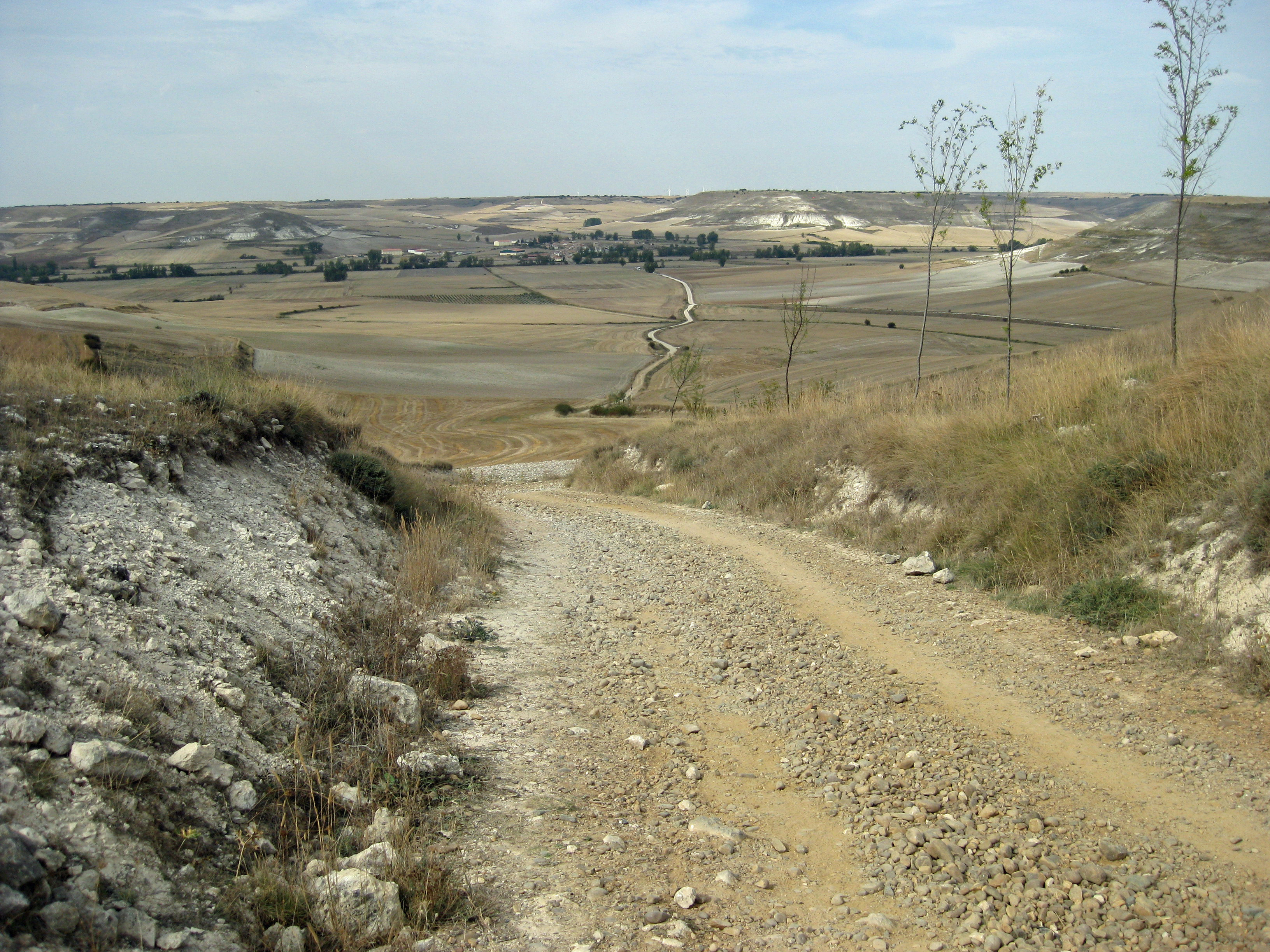
broad valleys.  Wheat fields stretch for as far as the eye can see, now freshly harvested in early October.  Rivers, lined with cottonwoods, meander through the plain.  Small medieval villages along the rivers break up the sameness of the terrain.

Like in so many developed countries, rural Spaniards are leaving the countryside for the cities.  This is especially true on the meseta.  The manager of the albergue in Caldadilla de la Cuesa tells me that only four children live in the village. "It is sad," she said, "This 10474459080?profile=originalwould be such a great place to grow up."  In many villages, most people I meet are elderly, walking with canes.

They say that if a pilgrim makes it as far as Burgos, (180 miles) she should be alright physically for the rest of the journey, but the meseta plays with the pilgrim´s mind.  The first part is not exactly true. Pilgrims´ feet are still breaking down after Burgos. Many must interrupt or end their journey because of blisters that won´t heal or painful, swollen ankle ligaments.  The meseta is cold and windy in the winter and brutally hot in the 10474481701?profile=originalsummer when most pilgrims make the journey.  The heat and seemingly endless monotony can drive the pilgrim to despair.

Hiking the meseta in autumn is beautiful.  Every day is sunny with temperatures in the high 70s.  Still, the meseta is challenging.  For three days the trail is totally flat, not even a small hill in sight.  It is like hiking across North Dakota.  My emotions quickly flip from, "Why did I ever want to take this long hike?" to feelings of euphoria to be so free and hiking such beautiful country.  Still, I look forward to reaching the big city ramble of Leon and the mountains of Galicia.

LEON (Day 22)

I enter the narrow, winding streets of the old city of Leon.  It is the day of the festival of San Froilan y las cantaderas, and a grand medieval faire fills the plazas 10474482293?profile=originalwith hundreds of booths selling roasted meats and octopus, pastries, sweets, jewelry, soaps, perfumes, clothes, wood carvings, and tarot readings.  People are dressed in renaissance costumes.  There are jugglers, tumblers, and drum and recorder bands performing for the thousands of people crowding the streets.

My wife, Heidi, arrives at midnight after a journey of four flights and 32 hours from our home in the San Francisco Bay Area.  After 22 days and 300 miles of hiking solo, I look forward to her joining me to hike the rest of the Camino.  I wait for her in the small plaza across from our hotel.  It is still hopping at midnight with celebrants spilling out of the bars that surround the square.

Our hotel, Hostal San Martin, is an aged stone and wood structure with a twelve10474482668?profile=original foot high, heavy wooden door, undoubtedly centuries older than any building still standing back in the Bay Area.  Inside, it is modern and comfortable.  It seems a metaphor for Spain, a very modern country that has preserved its ancient architecture and heritage for tourists and its citizens to relish.

We stay in Leon for three nights, giving Heidi a chance to adjust to the new time zone and for me to rest.  Exploring the city, we walk the banks of Rio Bernesga, visit the extraordinary and ornate gothic cathedral, the fanciful Gaudi designed Casa de Botines, and Convento de San Marcos - the former mother house 10474482697?profile=originalof the order of the Knights of Santiago, dating back to the sixteenth century.  It is now a luxury hotel but preserved like an unguarded museum with a Romanesque church, cloisters, gardens, and magnificent works of art.  We roamed its ancient corridors, opening doors, finding stone passageways and narrow stairways to explore, hoping to remember how to find our way out.

At night, the people of Leon come to the old city to play.  We join them at sidewalk tables of tapas bars and restaurants serving sumptuous grilled trout, roast lamb, and local red wines.  Leon, with a population of 130,000, is the third largest city along Camino Frances after Pamplona and Burgos.  It is the last large city we will visit until we reach Santiago.  In the morning we depart, rested and sated, eager to explore the mountains of Galicia and to hike the final 200 miles of el Camino de Santiago de Compostela.

CATHOLIC SPAIN (Day 29)

Spain has deep Roman Catholic roots, going back, legend tells us, to Christ´s apostle, St. James, Santiago.  The pilgrim passes through perhaps a half a dozen10474482870?profile=original 
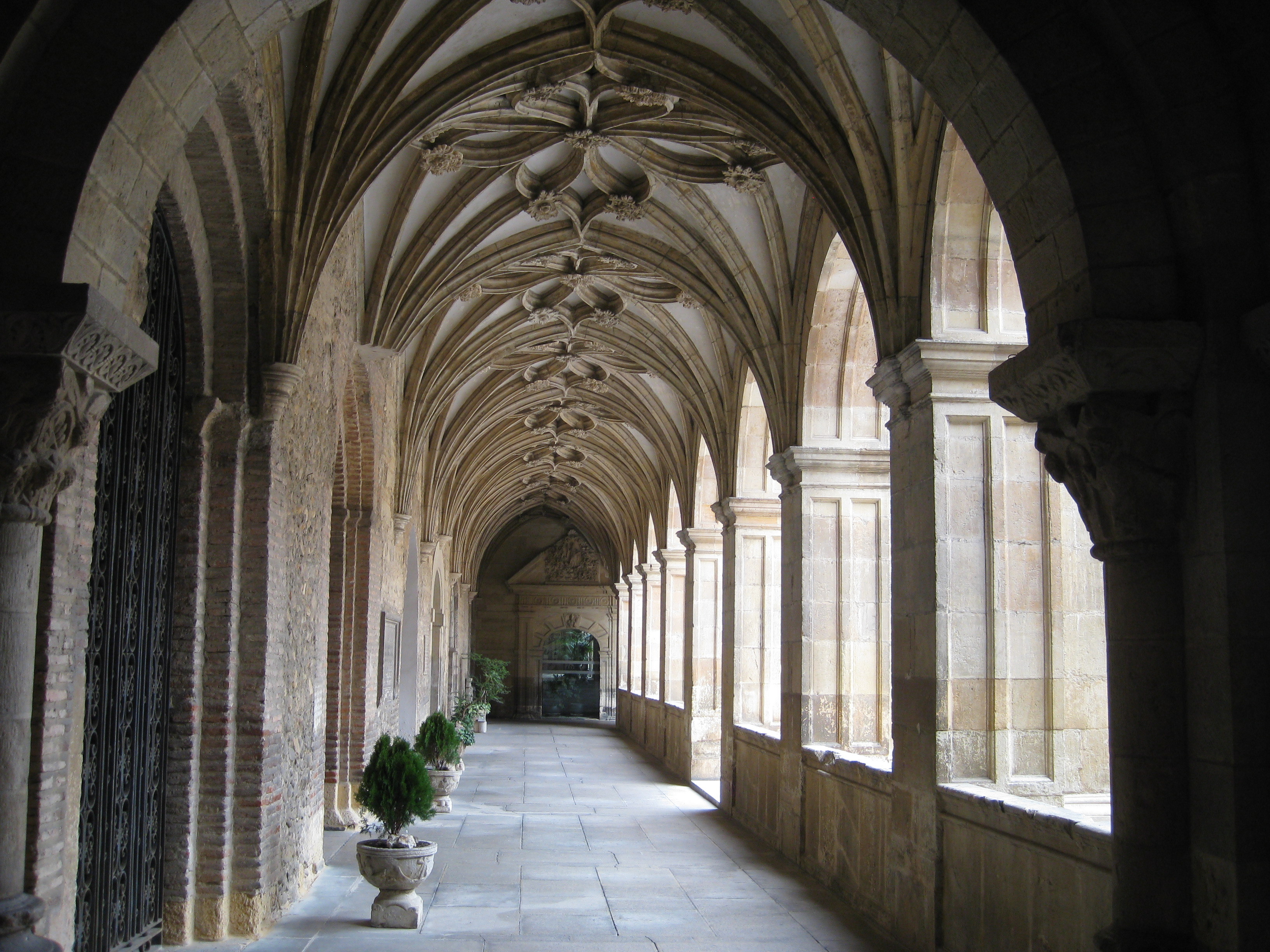
villages each day, almost all dominated by an ancient stone and wooden church.  We often stop to sit in the cool, dark sanctuaries for a moment of contemplation and to experience the beauty and devotion represented by centuries-old statues and paintings of the saints and Holy Family.  We have occasionally attended services in churches sparsely attended, and mostly by women fifty years or older.  Many services have no priest, just women reciting the rosary.

The large cities along the Camino have great cathedrals, dating back to the 13th century.  They are extraordinary, beautiful, colossal monuments glorifying the 10474482476?profile=originalChurch.  Built in an era when peasants lived in small one-story houses, the only large buildings one might ever see would be the cathedral, the castle of an aristocrat, or the bishop´s palace.  In Astorga, the grand, gothic cathedral and bishop´s palace, designed by the genius, Antoni Gaudi, at the end of the 19th century, stand side-by-side.  The palace is now a museum, and a portion of the cathedral houses another museum.  Both contain church treasures, room after room of gold and silver chalices, four-foot high processional crosses intricately crafted of silver and gold, the robes for priests and bishops sewn with pearls and golden thread.

Throughout Spanish history, the Church consistently sided with the wealthy over common people.  It supported Franco’s cruel and brutal Fascist regime, a memory fresh in the minds of many.  It is no wonder that the percentage of Spaniards who attend church is extremely low.

We hike out of Astorga, climbing the foothills of Las Montanas de Leon, for 14 miles to the beautiful village of Robanal del Camino.  Its stone houses stretch along the hamlet´s two streets.  That evening we attend a service with other pilgrims in the small Romanesque church, one small chamber formed by three semi-circular arches, with wooden pews.  Two elderly monks with pure voices transport us to another realm with an hour of Gregorian chanting in Latin.

Today is a national holiday honoring Spain´s military.  We move on to a more10474482501?profile=original secular celebration at an albergue.  As we enter the courtyard, village ladies hand us cups of thick, rich chocolate to drink.  The hostel is packed with pilgrims and villagers.  Wine and beer are flowing.  A three piece band with a fiddle, banjo, and drum strikes up a tune and then plays for three hours without pause, first Spanish love songs and then American folk music straight out of the Pete Seeger songbook.  A couple of two year old girls, one dressed as a princess, start a freestyle dance.  It isn´t long before we all join them.  Twenty-something pilgrims and villagers toss back shots of a yellow brew that inspires them to spring and bound.  Then they place their hands on the hips of the person in front of them and lead us, dancing in a long line, joyously snaking through the bar and courtyard.  Later, we stagger to bed, sleeping off the evening´s religious experiences, ready to continue our pilgrimage.

ENTERING GALICIA (Day 35)

Leaving the plains of north-central Spain, we climb and descend through the 10474463078?profile=originalmountains of eastern Leon and into Galicia.  As each day passes and the Atlantic Coast draws nearer, the terrain becomes more lush and verdant.  Ascending out of Rabanal for 1,000 feet, we reached the highest peak on the Camino, Cruz de Ferro, at 4,938 feet.  The trail passes through dense forests of oak, eucalyptus, birch, chestnut, and pine. Climbing out of Villafranca, the trail ascends 1,200 feet, drops 1,000, and then climbs another 2,300 feet to O’Cebreiro, entering Galicia, the final state on Camino Frances.10474461655?profile=original

Small farms replace the large grain fields of the maseta, and the Camino passes through a dozen small villages each day. Barns and fields are alive with sheep, cattle, hogs, and chickens.  Farmers shepherd their flocks from field to barn and back through the village’s main cobblestone street while the chickens free range the town.  Small pastures are lined with stone walls, and virtually all structures are made of stone.  10474481896?profile=originalThe roofs of houses and churches are now black slate, a change from the red tile roofs we have seen since the start of the Camino.

Descending into the deep valley of Rio Oribio, we visit the colossal and magnificent Benedictine monastery of Samos, one of the oldest in Spain, dating back to the 6th century.  We tour the large cloisters and gardens, the ornate 18th century church, and a small shrine room housing St. Benedict’s femur and a chalice with a thorn from Christ’s crown.  Once the home of hundreds of monks, today the massive monastery houses only 15 with just two novices trying to join the ranks.

We stay in lovely, modest pensions and hostals in farming hamlets.  At night, pilgrims gather in the one or two restaurants in the village to dine on Galician cuisine - fried octopus seasoned with paprika, fresh shrimp, pork, cheeses, 10474482896?profile=originalpastries, and local wines.

After 100 miles of hiking since Leon, Heidi’s blisters can no longer be denied.  She has bandaged, cushioned them with gel pads and soldiered on, hoping they will cure themselves, but they persist.  We decide to stop at a clinic in Triacastela.  After a 15 minute wait, the doctor pokes her head out of her office, invites Heidi in, drains and treats the blisters, and writes the names of the bandages and medicines Heidi will need.  They emerged from the doctor’s office laughing at the challenges of communicating with limited Spanish and English.  No charge.  The American medical system has so much to learn.

Next, on to Santiago.

SANTIAGO (Day 42)

The guidebooks warn of the fierce weather in Galicia.  Storms blow in from the Atlantic bringing wind, cold, rain, and snow.  But, the weather for us, in late 10474483080?profile=originalOctober, is ideal for hiking - crisp, cool mornings; warm, sunny afternoons.  In fact, I have only taken my rain jacket out twice during the six week pilgrimage because of slight drizzle.  Now, with the short autumn days, the leaves of oaks, maples, and chestnuts are turning yellow and orange.

We hike on narrow trails cut deep through the dense woods, sometimes fifteen feet below the forest floor.  Walls along the paths may be constructed of ancient stones or they may be solid earth held in place by deep roots.  It seems the route has been worn down by the footsteps of millions of pilgrims over 13 centuries, the boots of Roman legions before that, and the tracks of Celts going back to the Iron Age and the 8th century BCE.10474483471?profile=original

Two days out from Santiago, it starts to rain.  We welcome it, enjoying a chance to wear our rain gear and hike in the wet woodlands, stopping in village cafes to warm up with hot chocolate.  Approaching Santiago on the final day, a rainbow appears, arco iris.

Entering Santiago, we pass by dozens of aged churches, arrive in the old city, check into a hotel, and visit the pilgrim office.  The officials inspects our “credential del peregrino,” the document that every pilgrim carries.  Hostals, albergues, cafes, bars, and churches along the route stamp the pilgrim´s passport.  This verifies that she has made the journey.  We are issued a scroll, a compostela, written in Latin.  Our names - Adelaidem (Heidi) and Thomam.

There are several pilgrimage routes that all end in Santiago.  A pilgrim must hike the final 100km or bike the last 200 in order to receive the compostela.  The 10474463672?profile=originalofficials tell us that it is now the slow season and only 150 pilgrims a day finish the journey.  During the summer, the number swells to 1,500.  Over the first ten months, 170,000 peregrinos completed their pilgrimage!

The next day we enter the grand cathedral for the pilgrims mass.  It is the most fun I have ever had in church.  The knave of the massive structure is formed by 14 five-story Romanesque arches, but the decor is very Baroque.  Brightly painted wooden carvings of angels, cherubs blowing trumpets, and warriors on charging steeds with lances raised, support organ pipes stretching 30 feet to the ceiling.  Behind the altar, 20 foot high angels, gilded in gold, hold up a platform with giant maidens and Roman soldiers.  St. James, Santiago, is shown in his many10474483271?profile=original forms: a simple pilgrim, the Moor Slayer on horseback with sword raised, and in the center - seated on a throne bedecked with gold and jewels.  The bishop, wearing a miter, says the mass with a supporting cast of eight priest wearing white vestments and the red cross of Santiago.  A nun with the voice of an angel leads us in song.

A giant incense burner, the botofumeiro, hangs from a pulley at the ceiling by thick rope.  At the conclusion of the ceremony, a cluster of robed churchmen pull on the 10474483501?profile=originalrope in unison while one of their members gives it great shoves.  It swings back and forth across the long transept in a grand arc sometimes lifting the rope pullers off their feet.  These guys have one the best jobs in all of Christendom.  The sweet smell of incense fills the cathedral.  Then, the pilgrims milled around greeting friends they made along the trail.

The Camino de Santiago de Compostela teaches many lessons.  This is a topic of intense interest for pilgrims along the trail.  One cannot walk the Camino and be unchanged.  I think I will be processing what I have learned for many months, but here are a few lessons.  Solitude, community, and empathy.  The pilgrim walks long days at two miles an hour with endless hours of contemplation, but the shared experience and quest creates a deep community and caring for your fellow pilgrims.  There is great10474483876?profile=original joy in the simplicity of the pilgrim´s life.  You are carrying all your possessions, and you don´t want to add any more.  So, the pilgrim is divorced from the market economy.  She is single-tasking, rising in the morning and walking with only a few decisions to make - where to spend the night and to eat.  There is clarity of the day´s purpose and accomplishment.  What a change from our modern lifestyle.  What a wonderful gift.

Buen Camino!

This is a consolidation of several blogs from my pilgrimage on the Camino in autumn 2011.

Camino Resources

Here are a few resources that might be helpful for those planning to hike the Camino.  Please add some of your own.

10474483297?profile=originalGuides:

Brierley, John. “Camino de Santiago” www.caminoguides.comBrierly has guides for many of the routes to Santiago.

Raju, Alison. “The Way of Saint James – Spain”  www.cicerone.co.uk. Cicerone also has guides for cycling the Camino and for Camino del Norte.

Books:

Coelho, Paulo. “The Pilgrimage” NYC: HarperTorch, 1992.

Hitt, Jack. “Off the Road: A Modern-Day Walk Down the Pilgrim’s Route into 10474483901?profile=originalSpain” NYC: Simon & Schuster Paperbacks, 1994.

Moore, Tim. “Travels with My Donkey” NYC: St. Martin’s Press, 2004.

Alcorn, Susan. “Camino Chronicle: Walking to Santiago” Oakland: Shephard Canyon Books, 2006.

Kurlansky, Mark. “The Basque History of the World” NYC: Penguin Books, 1999.


Movies:

“The Way” Director: Emilio Estevez, Starring: Martin Sheen, Emilio Estevez, 10474483657?profile=originalDeborah Kara Unger.

“Walking the Camino: Six Ways to Santiago”   Director: Lydia Smith.

Websites:

www.caminoadventures.com. Sign up for a regular email newsletter.

http://johnniewalker-santiago.blogspot.com/. A wealth of information on the Camino.

www.thecaminoexperience.com. Help for first timers.

Read more…

Oceanside to La Jolla, Hiking Inn-to-Inn

Take an easy three day, 28-mile hike along this beautiful stretch of Southern California Coast from Oceanside to La Jolla.  You will join scores of beach lovers on10474471877?profile=original lively, popular strands, then hike long, quiet, and secluded beaches.  Along the way, you’ll visit fun seaside towns with great dining and entertainment.

Our hike starts on Oceanside City Beach where surfers, boogie boarders, distance swimmers, sun bathers, Frisbee throwers, power and dog walkers gather – a people watching feast.  Soon you leave the crowds and have the beach almost to yourself.  Hike along 10474473255?profile=originalthe ocean’s edge, and enjoy a bit of solitude and the beauty of the mighty Pacific.

The first day’s hike (7.7 miles) ends at Carlsbad, the second day (11.9 miles) at Del Mar.  Both towns have several options for inns, eateries, and watering holes.  Many of the inns will be happy to provide you with beach chairs, umbrellas, towels, and boogie boards.

Day 3 (8.4 miles) hikes through amazing Torrey Pines State Park, where 300 foot cliffs rise from the beach, topped10474473477?profile=original by stately trees.  Torrey pines are the rarest pine tree in the new world.  Stroll through the forest, then hike one of the most isolated and serene beaches on the Southern California coast.  Millions live nearby, but one must be a hiker to enjoy this splendor.

Continue south to hike the start of La Jolla Peninsula, a rugged coastline with sheer cliffs, pocket coves, and inviting beaches.  As you enter La Jolla, you are 10474473301?profile=originalgreeted by the barks of sea lions from the rocks below.  Stay an extra day and rent a kayak, paddle board, or snorkeling equipment and explore the clear waters of La Jolla Bay.  It is a great way to end a three-day immersion in the lifestyle and beauty of the Southern California Coast.

The Oceanside to La Jolla Walkabout is one of the multi-day hikes found in “Walkabout Malibu to Mexico: Hiking Inn-to-Inn on the Southern California Coast.”  

It can also be purchased as an individual guide.

$6.99

10474459675?profile=original

Read more…

Walkabout the Mendocino Coast

10474462478?profile=original

The Mendocino Coast is a land of extraordinary beauty.  Take a romantic two-day, 14.1 mile hike, and explore the lush forests of the coastal range and the headlands on the edge of the rugged, wild Pacific.  Along the way, you’ll visit interesting coastal villages, stay in charming inns, and enjoy sumptuous cuisine.

Our hike starts in Albion and heads north, ending in the town of Mendocino.  The Albion River Inn is one of our 10474462698?profile=originalfavorite places to stay on the California Coast.  It perches on cliffs overlooking a narrow bay, the mouth of Albion River, and the vast Pacific stretching to the horizon.  Their restaurant is fantastic.  They will serve you a delicious complimentary breakfast before you strike out.

The first day’s hike is an 8.3 mile ramble to Little River.  There is no trail along the coast for this section, so our route takes a quiet country road and ascends to the first coastal ridge.  Here we enter an eerie and rare Mendocino pygmy forest with hundred year old cypress standing only two feet tall and five foot high full-grown redwoods.  The terrain and foliage quickly changes as we descend into the lush redwood forests of Van Damme State Park.  Hike back to the coast on the trail along Little River as it meanders through the 10474463463?profile=originalwoods.  You’ll reach the town of Little River where there are several inns and B&Bs. 

Day 2 (5.8 miles) hikes along one of the most spectacularly beautiful coastlines in California – steep cliffs dropping to the sea, offshore outcroppings relentlessly pounded by the powerful Pacific, a verdant coastal terrace, and mountains dense with Sitka spruce, Douglas fir, and redwoods.  Keep an eye out for harbor seals, pods of dolphins, and migrating whales.

Stroll into Mendocino by walking the bridge over Big River.  You may want to stay10474463894?profile=original a few days to enjoy the many pleasures that Mendocino has to offer – fine dining, taverns, inns, and beautiful hikes along the headlands – and to savor the memory of an adventure on the Mendocino Coast, hiking inn-to-inn.

The Mendocino Coast Walkabout is one of a dozen inn-to-inn hikes found in “Walkabout Northern California: Hiking Inn to Inn.”  It can also be purchased as an individual guide.

$6.99

10474459675?profile=original“In my room, the world is beyond my understanding,

But when I walk I see that it consists of three or four hills and a cloud”
- Wallace Stevens

Read more…

Morgan Territory Regional Preserve is a land of rolling hills, forested valleys, beautiful vistas, and in the spring, a magical wildflower wonderland.10474473677?profile=original

The 5,000 acre park connects Mt. Diablo State Park, Round Valley Regional Preserve, and Los Vaqueros Watershed, creating an extensive network of hiking trails.  Yet it is one of the more seldom visited parks in the East Bay Regional Park System.

Summer heat turns the hills brown, but they are restored to brilliant green by winter rains.  In the spring, when the soil is moist and temperatures climb to the 70s, wildflowers emerge and grace the hills in great swaths of yellows, oranges, and blues.  We took this 5.5 mile hike in late March, just as the wildflower 10474474077?profile=originalshow was starting.  It peaks in April and should continue into May.

Our hike starts at the main entrance, Morgan Territory Road Staging Area.  The parking area had only two other cars.  You can grab a trail map as you enter or get a map online. 

Take the lower trail from the east side of the parking area and hike toward a small pond.  On the day of our journey, a pair of mallards paddled in the open water, redwing blackbirds trilled from shoreline reeds, and thousands of pollywogs swam in the shallows.

Turn left on Coyote Trail and enter a forest of oak, buckeye, and big-leaf maple.  The trail gradually descends along an unnamed seasonal creek that grows and cascades as small streams join it, draining the surrounding hills.

After 1.4 miles, you emerge from the woods into the open hills.  Turn right on 10474473876?profile=originalStone Corral Trail.  Now, the wildflowers get serious.  The park hosts 90 species.  We hiked past wild hillside gardens of yellow buttercups, red Indian paintbrush, blue-eyed grass, unfolding fiddlenecks, orange California poppies, deep blue lupine, and dozens of species we could not name.

Stone Corral Trail gradually winds and climbs the hills for 0.7 miles.  Raptors circled overhead.  The many ground squirrels scurrying among rock outcroppings look like a tasty meal.  Mt. Diablo (3,818 feet) suddenly comes 10474474452?profile=originalinto view to the northwest, a double pyramid towering over the countryside. 

Turn left on Volvon Loop, which circles Bob Walker Ridge.  On a clear day, you can see Mt. St. Helena 70 miles to the north.  Carquines Strait and the broad Sacramento-San Joaquin Delta spreads out below you.  The snow-capped peaks of the Sierra Nevada Mountains shine brightly, 150 miles to the east.

Turn left on Volvon Trail, and hike for two miles back to your car.  Gradually descend through open hills and groves of blue oaks, 50 feet high and wide with 10474474660?profile=originalspring leaves on a beautiful tangle of branches.  Manzanitas stand 20 feet high with gnarled trunks and smooth reddish brown skin.  Finish the hike with a stroll through a field dense with bright yellow buttercups.

Morgan Territory is a little bit off the beaten path but easy to reach.  Come in the spring and relish a wildflower spectacle.


Directions

From the south – Take N. Livermore Avenue north from Highway 580 in 10474474479?profile=originalLivermore.  Turn left on Manning when N. Livermore ends.  Turn right on Morgan Territory Road.  The road narrows to a winding single lane for the final four miles.  Morgan Territory Road Staging Area, the park entrance, is on the right.  It is 9.7 miles from 580 to the staging area.

From the north – Take Clayton Road from Concord to Clayton where it becomes Marsh Creek Road.  Turn right on Morgan Territory Road three miles from Clayton.  The staging area is 9.4 winding miles from Marsh Creek Road.

Read more…

Hiking Death Valley’s Dante’s Ridge

Our trail snakes along Dante’s Ridge following the crest of the Black Mountains.  10474461896?profile=originalDeath Valley is a land of contrast.  It is hot in the valleys below but pleasant up here in the mountains.

Many people drive to Dante’s View (5,475 ft.), and some take a short hike, walking south from the parking area to viewpoints along the ridge.  Our trail heads north and climbs for a half mile to Dante’s Peak (5,704 ft.).  A handful of 10474461681?profile=originaladventurers continue another half mile to a viewpoint.  After that, you can expect to have the trail pretty much to yourselves.  We hiked out 3.5 miles and saw only two other hikers.

The ridge trail is not formally named or maintained, but it is easy to follow and a joy to hike.  It roller coasters along the ridge.  To the west, the view drops steeply to Badwater Basin, 282 feet below sea level.  Then the Panamint Range soars abruptly to Telescope Peak (11,043 ft.), the tallest mountain in Death Valley 10474462688?profile=originalNational Park.  To the southwest stands Mt. Whitney at 14,505 feet.  The distance between the lowest spot in North America and the highest peak in the lower 48 states is a mere ninety miles. To the east, the Black Mountains descend to the broad Greenwater Valley.  Greenwater Range borders the valley, and in the distance stands the tall desert peaks of Nevada.

It was early March.  Wildflowers ran riot at the low elevations, and the high mountains were snowcapped, glistening in the mid-day sun.  The thermometer hit 90 degrees in valleys below, but on the ridge trail it was in the low 70s, and a gentle breeze refreshed us.  Even in the summer, this trail will give you a blessed relief from the scorching lowlands of Death Valley.

It is more than a mile down to Badwater Basin, greater than the depth of the Grand10474463095?profile=original Canyon.  Death Valley is the driest place in North America, averaging only 2 inches of annual rainfall.  The meager runoff flows from the mountains into the basin and evaporates, leaving a salt flat.  More recent flows form amazing patterns of new clean crystals, white sediment against the older, grayer basin floor.  The remnants of evaporated rivers leave bright white snaking patterns leading to dried pools.

The trail is mostly sand and gravel with a few rocky outcroppings.  It rises and falls along the ridgeline with a couple of long descents.  At 2.7 miles, it changes to rocky 10474463694?profile=originalterrain and starts to climb.  Our pace slowed, and we kept our eyes peeled, watching for cairns that mark the trail as it winds through the boulders.  At this point, there were very few boot prints on the trail.

Reaching the foot of Mt. Perry at 3.5 miles, our time was running out, and we reluctantly turned back.  The return journey was even more beautiful as the shadows lengthened in the late afternoon.  There are so many great trails in Death Valley National Park.  Add this on to your list.  It is truly spectacular.


Safety

This may not be your trail if you suffer from vertigo.  Wear good hiking boots.  We appreciated our hiking poles.  Always bring plenty of water on a Death Valley hike.  10474463879?profile=original                                                                    


Directions

Drive Highway 190 southeast from Furnace Creek for 11 miles to the turnoff to Dante’s View.  The Dante’s View road winds through the desert for eight miles and then climbs another six to the Dante’s View parking area.  The ridge trail starts at the north end.

Read more…

Hiking the Sonoma Coast

There are few better ways to nourish the spirit than to stroll a hidden beach while 10474469266?profile=originalthe powerful Pacific pounds offshore outcroppings, sending cascades high into the air.  And there are few better places to savor this experience than California’s spectacular Sonoma County Coast.  Take the Kortum Trail as it snakes for five miles along coastal bluffs.

     We set out on a sunny February afternoon at the southern end of the Kortum, seven miles north of Bodega Bay, at the Wright’s Beach turnoff.  The trail heads north from the bluff-top parking lot and meanders10474469292?profile=original along the coastal terrace.  Willow and blackberries crowd watercourses that drain the hills.  Spring will bring natural gardens of California poppies, irises, seaside daisies, yarrow, buckwheat, and lupine. 

     After a mile we reached the Carlevaro Way access road where the trail turns to the coastal cliffs.  We stopped at the first promontory to take in one of the most stunning coastlines in California.  Steep cliffs 10474469699?profile=originalplunge to pocket beaches.  Coastal shallows are crowded with rock outcroppings and sea stacks relentlessly battered by crashing waves.

     The trail reaches the Shell Beach access road at 2.5 miles.  Take a side trip to the beach or continue north through tall grasses and marshland.  A boardwalk traverses the wettest sections.

     The Kortum turns inland and starts a gradual ascent around the 3.5 mile mark.  We reached a pass and stopped to take in breathtaking views of the coastline and the surrounding lush and verdant hills.  This section of the coast is protected as part of Sonoma Coast State Beach, 10474470673?profile=originalstretching 17 miles from Bodega Head to four miles north of Jenner. 

     Descending to the Blind Beach parking lot, we saw that the tide was low.  That allowed us to hike down to the beach and along the shore to Goat Rock at 5.0 miles.  The official Kortum Trail continues along the bluffs from the Blind Beach parking lot, paralleling Highway 1 and Goat Rock Rd.

     Goat Rock is a massive monolith connected to the shore by a narrow isthmus.  We continued another half 10474470292?profile=originalmile along steep Goat Rock Beach to the mouth of the Russian River across from Jenner. 

     Harbor seals played in the surf where the river meets the sea.  Dozen lounged on the beach, joined by brown pelicans.  This narrow beach becomes a nursery from March to July where hundreds of harbor seals come to give birth and nurse their young.  Signs and volunteers warn visitors to stay back at least 50 yards in order to not disturb the mothers and babies.10474471072?profile=original

     Hiking back to our car, the cliffs glowed in the setting sun.  Our pace slowed.  It had taken us five leisurely hours to traipse the 11 mile journey, but we were in no hurry to leave this beautiful coast.


Best Times to Visit

Any time of year is good.  Choose a sunny day.  Check the weather report for winter rains or summer fog and wind.


Directions

Kortum Trail starts at the bluff parking lot 10474471467?profile=originalabove Wright’s Beach and travels north.  Take California Highway 1 north from Bodega Bay for seven miles or five miles south from Jenner.  The trail can also be accessed north of Wright’s Beach at Carlevaro Way or the Shell Beach parking lot.

Read more…

Skiing Mt. Rose's Tahoe Meadows

If you are in the Tahoe-Reno Area and looking for a great place to cross-country ski or snowshoe, it’s hard to beat Tahoe Meadows.  Park your car and head out on a10474467290?profile=original long gradual descent through the wide valley.  You can follow trails made by others or blaze your own, exploring the meadows or the surrounding mountains.

          We set out on a sunny afternoon with temperatures in the mid-30s.  It had been two days since the last storm.  The boughs of the pine forests that line the meadow were heavily laden with snow, and there was foot of light powder.  Conditions were perfect!

          We followed a trial down valley for a half mile, and then turned west into the woods, ascending, zig-zagging through the trees for another mile and a half.  10474468472?profile=originalReaching the crest at 9,225 feet, Lake Tahoe emerged below us, deep blue, surrounded by snowy peaks.  There are few more beautiful sights in all of California.

          This spot is called Chickadee Ridge.  There is a small bird feeder, and dozens of chickadees flited from tree branch to feeder.  They are tiny gray birds with white cheeks and a black crown and bib.  Fearless and curious about us, they flew over to land on our caps and shoulders.

          The descent to the meadow was sheer joy.  Breaking trail, the deep powder made it easy to snake between the trees, effortlessly gliding through the woods.  We took our time, enjoying the still beauty of the winter forest.10474469062?profile=original


Directions

Tahoe Meadows, at 8,500 feet, is on the southeast flank of Mt. Rose.  From Lake Tahoe’s Incline Village, drive east on Mt. Rose Highway (Hwy. 431) for 6.5 miles.  From Reno, drive west on Highway 431 for 17.2 miles from the Highway 395 junction.  You will see a long parking area by the side of the highway.  Snowmobiles are limited to the north side.  Tahoe Meadows is on the south.

Read more…

Hundreds of northern elephant seals line Año Nuevo Beach – babies crying, mothers snorting, giant males roaring and defending their territory.  Mostly they 10474459654?profile=originalare resting between birthing, nursing, mating and fighting, densely splayed along the sandy peninsula.

On a clear January morning, Ed, our volunteer guide, led us through sand dunes and thickets of willows.  He directed us on a winding path, giving wide birth to scattered single males. 

Cresting a dune, we starred in awe.  Scores of the pinnipeds lay fifteen feet below us.  Enormous males, 14-16 feet long, weighing two and a half tons, lay among their harems.  Their large, pendulous proboscis resembles an elephant’s trunk and gives the species its name. 

A male bachelor came too close, and the alpha bull reared and roared.  He 10474459885?profile=originallumbered toward his opponent, and the offending bachelor quickly retreated.  A mother cried, warning her pup to get out of the way to avoid being crushed.

Ed led us to another dune where a sandy peninsula stretched to the sea.  We looked down on an incredible wildlife scene, one of the largest breeding colonies of elephant seals in the world.


When to Go

Winter is the best time to visit, from mid-December to early March.  The males10474460280?profile=original arrive in December, and bloody, violent fights for territory and dominance begin.  The winners, alpha bulls, gather the arriving females into harems of around 50 but some up to 100.  This is a rewarding but exhausting job.  A male will live for around 14 years, but it is rare for an alpha bull to maintain his dominance for more than one year.

          Within a few days of arrival, the females give birth to a single pup that weighs about 75 pounds. The pups nurse for less than a month and grow 10474460855?profile=originalto 250-300 pounds!  The females mate several times with the alpha bull.  A bachelor might also sneak in for a quick mating.

          A month after giving birth, the females abruptly leave, deserting their pups.  By mid-march, almost all the adults have set out to sea.  The pups stay at Año Nuevo for another month, molting, losing their black fur for a silver coat.  They venture into the shallows to practice swimming and diving.  By the end of April, they leave, heading out into the Pacific to hunt for food.


An Incredible History

Valued for their blubber, which was used to make lamp oil, the northern elephant seal was hunted to the brink of extinction.  By the 1890s, only around 40 were known to still exist, breeding on Guadalupe Island off the coast of Baja.  Mexico and the U.S. outlawed hunting the seals in the 1920s.  Their recovery has been spectacular.  Today, their estimated numbers have climbed to 124,000.10474460681?profile=original

          The first modern-day elephant seals arrived on Año Nuevo Island in 1955, and the first pup was born in 1961.  Today, more than 3,000 come to the island and mainland annually.


Where do they go?

Leaving their breeding grounds, the males strike out on one of the longest migrations of any marine mammal, a 7,500 mile journey.  Swimming north to Alaska and the Aleutians, they gorge on small sharks, octopus, skates, and eels.  They return to Año Nuevo for a month between May and September to molt, shedding patches of fur and skin, for a new coat.  Then they head back to sea to bulk up for the next mating season.

          Females migrate off the continental shelf to the deep Pacific where they feed on fish and squid.  Sharks, especially great whites, are the greatest threat, so they dive to depths the sharks cannot reach, sometimes more than a mile!  They return to Año Nuevo to molt for a month between April and June.


Tours and Cost

During the prime season, from December 15 to March 31, visitors must join a 10474461096?profile=originalnaturalist-guided walk.  They last two and a half hours and hike three miles.  The cost is $7 plus a state park parking fee.  For reservations, call 800-444-4445 or go to Anonuevo.reserveamerica.com.


Directions

Año Nuevo State Park is on Highway 1.  Drive 35 miles south from Half Moon Bay or 20 miles north from Santa Cruz.

Read more…

Calaveras Big Trees – Winter in the Sequoias

We glide effortlessly, cross-country skiing in Calaveras Big Trees State Park.  Branches sag, heavy with snow.  The air is crisp, and woods quiet.  After leaving the10474465481?profile=original visitor center parking lot, it took only ten minutes before we were alone.  There is solitude and a deep connection with nature that comes easily when you venture into a snowy forest.


Winter Activities

The park is in the foothills of the Sierra Nevada Mountains.  It has two cross-country skiing and snowshoe trails.  The 3.5-mile Parkway Loop Ski Trail climbs though forests of ponderosa pines, sugar pines, and incense cedars dotted with sequoias to an overlook of the Sierra.  The 1.5-mile North Grove Ski Trail loops through a world famous redwood grove.

          It had been three days since the last snowfall when we set out.  The Parkway Trail was a bit chewed up by snowshoes but its long gradual hills were a joy to ski.  10474466067?profile=originalThe trail through the North Grove was trampled solid by hikers, so we walked.  It is awe-inspiring to traipse among the redwoods, when the forest has a deep blanket of snow.  If you catch it during or soon after a snowfall, you can experience the towering giants on skis.

          Sledding is also popular, and families were frolicking on long runs near the visitor center.  Check on snow conditions by calling the visitor center (209)795-3840 or (209)795-7980.


The Sequoias

California’s giant sequoias are the largest trees on earth, ranging over a narrow, 206-mile band of the western slope of the Sierra 10474466493?profile=originalNevada Mountains between 4,000-8,400 feet.  There are 75 distinct groves, and two of them reside within the park.

          Early pioneer journals mention sightings of enormous trees, but they first came to the public’s attention in 1852.  Tracking a wounded grizzly, Augustus T Dowd wandered deep into the woods when he came upon a forest of colossal trees, much larger than any he had ever seen.  After the hunt, he brought others to see 10474466677?profile=originalthe giants, and the word spread.  The forest that Augustus stumbled upon is now the North Grove of Calaveras Big Trees State Park.


Equipment and Rentals

You can rent skis and snowshoes in Arnold, just 4 miles west of the park on Highway 4, at Sierra Nevada Adventure Company (209)795-9310 or Ebbetts Pass Sporting Goods (209)795-1686. Walking the park’s trails can be slippery, but attaching traction devices to your boots gives a firm grip on ice and snow.  They can be purchased at sporting goods stores.  We use ICEtrekkers.  Some10474467101?profile=original other brands are Yaktrax, Kahtoola, or STABILicers.  


Places to Stay

There are four cabins for rent within the park starting at $165.  A Google search will turn up several inns in Arnold and lots of VRBO options.  Angels Camp is 25 miles from the park on Highway 4 and also has 10474467660?profile=originallots of lodging options.


Directions

To reach Calaveras Big Trees State Park, drive 35 minutes east on Highway 4 from Angels Camp.  The park is four miles beyond Arnold and 2.5 - 3 hours from the Bay Area.  For road conditions, call 1-800-427-7623.

Read more…

Bryce Canyon – a Winter Wonderland

Add Bryce Canyon National Park to your bucket list for spectacular winter beauty, hiking, skiing, and snowshoeing. We visited in late December.  A blanket of snow brought a peacefulness that10474470899?profile=original was a contrast to the busy summer season.  The crowds had thinned, the air was clear, and views stretched for 100 miles.


Hoodoos

Ancient rivers eroded the edge of Southern Utah’s Table Cliff Plateau forming pinnacles, spires and fins called hoodoos.  They are the “Legend People” of Piute lore, turned to stone by Coyote.  Walk the Rim Trail or drive the park’s road, stopping at overlooks.  The 10474472082?profile=originalviews are breathtaking and ever-changing, a photographers dream.


Hiking

Winter hiking on steep trails can be dangerous, but attaching traction devices to your boots gives you a firm grip on snow or ice.  You can buy them at sporting goods stores or at the park’s visitor 10474467101?profile=originalcenter.  We use ICEtrekkers.  Some other brands are Yaktrax, Kahtoola, or STABILicers.   

On a bright, sunny day we descended into Bryce Amphitheater from Sunset Point on popular Navajo Loop Trail.  Reaching the canyon floor, we took the 3.7 mile Peekaboo Loop.  The snow was deep, but others had broken trail.  Hiking through forests of pinyon pines, fancifully shaped hoodoos towered around us.  We only saw only two other hikers on Peekaboo.10474471668?profile=original

We returned to the rim on Queens Garden Trail.  This section has some of the most fantastic and whimsical formations.  We hiked through tunnels carved in the soft rock and assigned names to the hoodoos. “That one looks like a woman on a horse.” “There’s Abraham Lincoln!” A short side trail leads to a spot where if you use your imagination, you can see Queen Victoria overlooking her court.  Many of the courtiers wore tall white hats of snow.

10474472492?profile=originalReaching the rim at Sunrise Point, we strolled the half mile back to our car.  The sun was dipping low in the west, casting long shadows from the hoodoos, such an eerie and beautiful sight, a great way to end our six-mile hike.


Winter Sports

Within the park, there are many cross-country ski routes above the rim.  Just outside the park, Ruby’s Inn offers 30km of groomed trails and ski rentals.

 Ruby’s also rents snowshoes for inside or outside the park.  Day time ranger-led snowshoe hikes start from the visitor center, and full-moon hikes are offered from November to March.  Snowshoes and poles are provided free of charge.  Call the visitor Center, 435-834-4747 for information and reservations.10474472675?profile=original

Ruby’s also has a skating rink and rentals.


Where to Stay

Lodge at Bryce Canyon is the only lodging within the park.  It was built in 1925, but 2015-16 is the first time it will stay open all winter.  Rooms start at $121.

Ruby’s Inn is just outside the park.  Bryce View Lodge is across the street from Ruby’s.  Rooms for both start at $70.

Read more…

Cosumnes River Preserve – A Birding Paradise

It is dusk, and the pale December sun dips toward Mt. Diablo.  A guttural, trumpeting call comes from a group of sandhill cranes.  They glide in V-formation, long necks extended, legs stretched behind.  Descending to the harvested cornfield, they slow and break formation.  An abrupt turn, wings flapping to slow down, feet hit the ground with two awkward steps, wings fold, and they join hundreds of compatriots for the night.

10474464071?profile=originalThis scene is repeated, one group after another, on Staten Island in Cosumnes River Preserve.  They join thousands of other birds to settle in for the night.  We feel like we’ve stepped back in time to when humans were a minor species, and the skies of California’s Central Valley were darkened with flocks of migrating birds.

Just north of Stockton, the preserve is a short drive from most of the Bay Area or Sacramento, and it’s a nice place to take a break when you’re driving Highway 5.  Outdoor writer, Tom Stienstra, reports that an average of five million ducks and 1.5 million shorebirds migrate through or over-winter on California's Pacific Flyway. The ponds, marshes, river, and fields of Cosumnes are a major stopping point.

But sandhill cranes are the stars.  They stand five feet tall on legs that bend backward at the knee. Their plumage is gray with a red crown of featherless skin that turns bright when they are excited.  With long, stately necks and a seven foot wingspan, they have a dignified, ancient appearance.  Their roots are prehistoric, with fossil records dating back 2.5 million years.10474464457?profile=original

A mated pair begins a courting ritual – circling, leaping with wings spread, calling in a complex duet.  They stretch their necks, toss heads back, and fling sticks and grass in the air – a joyous bonding dance.

Exploring the Cosumnes River Preserve

Hiking

Bird watching is not the only fun activity in the preserve.  Stop by the Visitor Center for a trail map.  You can stretch your legs and hike three miles on the River Walk Trail as it snakes through oak forests, open fields, on levees, and along the Cosumnes River.  Meander on the one-mile Lost Slough Wetlands walking through marshlands and ponds.  The ½ mile Boardwalk Trail winds deep into ponds for an up-close look at ducks, geese, herons, egrets, and dozens of other species.


Kayaking

Cosumnes River is the last undammed river flowing out of the Western Sierra.  It joins Mokelumne River in the Sacramento-San Joaquin Delta, just downstream from the preserve.

 10474464889?profile=original           We put in on Middle Slough, near the Visitor Center, and paddled our inflatable double kayak through riparian forests.  Red-tailed hawks circled overhead.  A great egret with flowing white plumage waded near the shore.  She stopped, leaning forward.  Then lightning-quick, she pierced the shallows with her long beak and snatched a wriggling fish. Gulp.  After gliding a ½ mile of still water on the slough, we came to the river and explored the main channel and backwaters for a few hours.


Bring the Kids

Families with young children and toddlers in strollers were enjoying the preserve on the day of our visit.  The kids delighted in spotting rabbits and ground squirrels.  They shared in the excitement of watching hundreds of birds get spooked, suddenly take off, and circle overhead, or of seeing a skein of Canada geese glide in for a splashy landing on a pond.


Best Times to Visit

Millions of birds migrate on the pacific Flyway from fall through spring.  When winter storms hit Northern California, waterfowl head for the Central Valley and Sacramento-San Joaquin Delta.  The greater sandhill cranes arrive in 10474465097?profile=originalOctober and over-winter on the preserve.  Lesser sandhill cranes pass through on their way to Mexico from their breeding grounds in Siberia, Alaska and Canada.  The best time to see cranes is around dawn and dusk.  Drive Staten Island Rd., pullover, get out, and watch a spectacular show as hundreds fly out of the fields in the morning and return late in the day.


Getting There

The Visitor Center, 13501 Franklin Blvd., Galt, CA.  is approximately 25 miles north of Stockton. 

Driving north on Highway 5: Take exit 493, and drive north on Thorton Rd. to Franklin Blvd.  Continue on Franklin.  Look for the Visitor Center sign

Driving south on Highway 5: Take exit 498, turn left (east) on Twin Cities Rd, right on Franklin Blvd.  Look for the Visitor Center sign.

The Visitor Center will provide you with directions to great viewing sites including Staten Island Rd and Woodbridge Ecological Reserve.

Read more…

Marin Coast Walkabout - A Trail Change

The Marin Coast Walkabout is a 4-day hike from Marin Headlands to Point Reyes National Seashore.  There has been a major trail change on Day Three – from Stinson Beach to Bolinas.  The route starts out unchanged, leaving Stinson, climbing to Bolinas Ridge and hiking the Coastal Trail to Bolinas-Fairfax Road.  Bourne Trail is now neglected and overgrown.  Here are two alternative routes.


First Alternative:  Cross Bolinas-Fairfax Road and hike Bolinas Ridge Trail.  It starts in serene redwoods, emerges into an open manzanita and oak forest, then back to redwoods.  Continuing along the rolling ridgeline, the forests alternate for 3.5 miles until McCurdy Trail.  Descend McCurdy for 1.7 miles to Highway 1.  This is not a well maintained trail, but it is popular with mountain bikers who keep it from becoming overgrown.  Initially it is steep, but it soon enters the forest and becomes more gradual.  Leaving the forest, hike the final mile through beautiful, rolling grasslands, descending into the wooded Olema Valley.  You are walking down to the San Andreas Fault.

Turn left on Highway 1 for a brief walk on the shoulder.  Turn right on Horseshoe Hill Road, a quiet forested country lane passing by small homesteads.  Turn right on Olema Bolinas Road, and hike the walking path along the road into Bolinas.


Second Alternative:  Descend from the ridge on Bolinas-Fairfax Road.  We try to avoid walking on roads, but this one is very pretty with little traffic.  It winds through the forest with periodic windows that open to Bolinas Lagoon and the Pacific.  Hike the road for 4.3 miles to Highway 1.  Cross the highway and walk the path along Olema Bolinas Road into Bolinas.

Read more…

Inn to Inn Hike around Marin

marin%20headlands%20start%20at%20Mountain%20home%20inn%20october%2019th%20Rev%201.%20docx.docx  Tom,  read your book several years ago and put together a hike similar to yours in Marin ....it was a great time ....Next stop the Cotswalds in England .  I have attached the file with each days route with a link to walkwithGPS.com and the hotels I stayed at ...I Just dropped stuff off at the hostel...the rest of the days I just carried my wifes and my clothes

Regards Dave Dryer

Read more…